Tocht Trail Gemeinde St. Leonhard im Pitztal - Pitztal  - Photo
 ppou
ppou

Gebruiker

© OpenStreetMap contributors
Lengte
Lengte
637 km
Max. hoogte
Max. hoogte
3259 m
Positief hoogteverschil
33023 m
Km-Effort
Km-Effort  
1086 km
Min. hoogte
Min. hoogte
47 m
Negatief hoogteverschil
35595 m
Boucle
Boucle
Neen
Datum van aanmaak :
2023-07-18 09:42:27.0
Laatste wijziging :
2024-08-13 18:01:07.277

(0 Bericht)

Trail
Trail
5h44
Moeilijkheid : Medium

Scan deze QR-code om de tocht te openen in de SityTrail-applicatie

Gratisgps-wandelapplicatie

Logo SityTrail SityTrail

IGN / Geografische instituten

SityTrail uit de App Store downloaden SityTrail uit Google Play downloaden

Logo SityTrail SityTrail World

De wereld gaat voor u open

SityTrail uit de App Store downloaden SityTrail uit Google Play downloaden SityTrail op Huawei AppGallery downloaden

Over ons

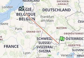
Tocht Trail van 637 km beschikbaar op Tirol, Bezirk Imst, Gemeinde St. Leonhard im Pitztal. Deze tocht wordt voorgesteld door ppou.

Hoogteprofiel

Foto's

Plaatsbepaling

Land:
Austria
Regio :
Tirol
Departement/Provincie :
Bezirk Imst
Gemeente :
Gemeinde St. Leonhard im Pitztal
Locatie:
Unknown
Vertrek:(Dec)
Vertrek:(UTM)
644313 ; 5198418 (32T) N.

Wandeltochten in de omgeving

Tocht Te voet Gemeinde Sölden - Sonnberg-Höhenweg - Photo
Te voet
GUIDE+

Te voet

Gemakkelijk
Gemeinde Sölden, Tirol, Bezirk Imst, Austria
4,6 km | 7,2 km-effort
1h 38min
Neen
Tocht Te voet Gemeinde Sölden - Venter Höhenweg - Photo
Te voet
GUIDE+

Te voet

Gemakkelijk
Gemeinde Sölden, Tirol, Bezirk Imst, Austria
9,7 km | 13,8 km-effort
3h 8min
Neen
Tocht Trail Gemeinde St. Leonhard im Pitztal - Braunschweiger - Photo
Trail
ppou

Trail

Medium
Gemeinde St. Leonhard im Pitztal, Tirol, Bezirk Imst, Austria
7,8 km | 23 km-effort
2h 38min
Neen


Sluiten
Mijn abonnementen